
Tropical Cyclone Nivar: What Happened in November 2020
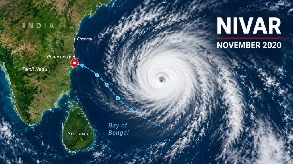
Tropical Cyclone Nivar crossed India’s southeast coast in the early hours of 26 November 2020. For a few tense days it looked like Chennai might relive its worst flood memories. It didn’t. The storm was strong, but the preparation around it was stronger.
This guide covers how Nivar formed, what forecasters got right, where it hit, and what it cost. Whether you’re a student, a researcher, or someone who watched the rain from a Chennai window, you’ll get the sequence of events in plain language, with sources at the end.
What Was Cyclone Nivar?
Nivar was a very severe cyclonic storm. It was the fourth named storm and the eighth depression of the 2020 North Indian Ocean season. At its peak, the India Meteorological Department (IMD) measured sustained winds of 120 km/h and a central pressure of 982 hPa, while the Joint Typhoon Warning Center, averaging over one minute, put the winds at 130 km/h. That gap comes from the measurement method, not from any disagreement about the storm itself. WikipediaWikipedia
Was it huge? Not by Bay of Bengal standards. Amphan, earlier in 2020, was far more powerful. But wind speed tells only part of the story. Nivar’s danger came from heavy rain, a crowded coastline, and a city with a painful flood history.
How Nivar Formed: A Timeline
The system grew out of a disturbance in the Intertropical Convergence Zone. The IMD and JTWC both reported a depression on 23 November, upgraded it to a storm the next day, and the IMD assigned the name Nivar.
- 23 November: A depression sat over the south-west Bay of Bengal, about 700 km south-south-east of Puducherry, and the NDRF began sending six teams to Cuddalore.
- 24 November: The system became a named cyclonic storm.
- 25 November: It strengthened into a very severe cyclonic storm. Tamil Nadu declared a holiday and suspended transport services.
- 25 to 26 November: Landfall near Puducherry.
- 27 November: The remnants dissipated.
The Forecast That Held Up
Here’s what deserves real credit. The IMD’s first track forecast, issued at 5:30 am IST on 23 November, placed landfall between Karaikal and Mamallapuram, close to Puducherry, three days in advance. The cyclone crossed near Puducherry.
That window was wide. Mongabay-India described it as a stretch of about 200 km. Models also disagreed late in the game. One pointed to Puducherry, while the European model suggested a crossing between Mamallapuram and Kalpakkam, where a nuclear power station sits. The plant’s operators activated cyclone protection measures, including sandbags and drain clearing.
A wide window is still useful. It’s enough to move people, stage rescue teams, and shut off power where wires might fall.
Landfall: The Night of 25 to 26 November
The IMD said Nivar crossed the coast near Puducherry between 11:30 pm on 25 November and 2:30 am on 26 November, then weakened to a severe cyclonic storm. Reference accounts place the crossing near Marakkanam, between Puducherry and Chennai. Exact timing varies between reports. That’s normal, since landfall is a process, not a single instant.
Gusts reached up to 130 km/h, trees came down, and some areas got up to 30 cm of rain within a few hours. Power had already been cut in advance to protect the electricity grid. After crossing, the system moved inland. The Nellore district in Andhra Pradesh recorded the state’s highest rainfall, 245 mm.
Chennai and the Chembarambakkam Question
Chennai wasn’t at the center, yet the rain still arrived. The city logged 163 mm in the period ending at 8:30 am on 25 November, and waterlogging closed roads and flooded areas like Madipakkam, Velachery, and Adambakkam. Central neighborhoods such as K K Nagar, Ashok Nagar, and Egmore also had water in the streets.
Then came the lake everyone in Chennai watches nervously. Chembarambakkam’s shutters opened on 25 November, reportedly for the first time in five years. The fear is historical. Many people believe a huge release from this lake worsened the 2015 flood, in which over 300 people died.
Officials did it differently this time. Discharge started at 1,000 cusecs at noon and climbed to 7,000 cusecs that night, holding the level near 22 feet against a 24-foot capacity. Gradual beats suddenly. Every time.
One uncomfortable detail: reporting suggested a planned desilting project for Chembarambakkam and three other reservoirs had slipped because of the pandemic. Maintenance delays like that quietly shrink the buffer a city depends on
Casualties, Damage, and Evacuation
The evacuation was the headline. More than 2.7 lakh people moved into shelters, and loss of life and property damage were contained, although farmland and residential areas flooded in many districts. That happened during COVID-19. In Cuddalore alone, over 50,000 people went to 233 government shelters.
What about deaths? Early reports disagreed. Police said a 47-year-old woman died when her house collapsed at Konur near Villupuram. Other reports carried the same claim, but local authorities said there was no loss of life. One widely used reference lists 14 deaths and about $600 million in damage across all affected areas, including Sri Lanka. I’d treat both figures as estimates, since final tallies differ by source. Cyclone Nivar: One dead and torrential rains as a huge storm makes landfall in India +2
A Rare Silver Lining
Not all the rain was unwelcome. The IMD’s S. Balachandran told Mongabay-India that Tamil Nadu’s seasonal rainfall deficit fell from 23% to 15%, while Puducherry moved past 13% above normal. Mongabay
Same water, different address. Rain that refills reservoirs also floods streets, which is why drainage and storage planning matter as much as forecasts.
Lessons From Nivar
Nivar wasn’t a disaster, and that’s the point worth studying. Four things stand out:
- Early, specific forecasts. A three-day track gave officials time to act.
- Pre-positioned rescue teams. NDRF units were in Cuddalore before the first heavy band arrived.
- Phased reservoir releases. Slow, announced discharges avoided a repeat of 2015.
- Maintenance before monsoon season. Desilting can’t wait for a cyclone warning.
My honest view? The forecast was the real success story. Everything else depended on it.